Oconaluftee Indian Village
on the
Oconaluftee River in Swain County NC
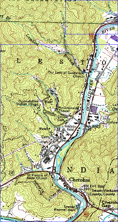
This is part of Whittier NC 7�' USGS 1:25,000 Topo Quadrangle Sheet
To see more of this quad east, west, & south sides of the south 4/5 of this
map (the original part of this map), click on the south 4/5 of this map,
below the line. It will take you to TopoZone.Com where I got the
original part of this map.
To get the above map, I combined 2 tiles (maps) wide by 4 tiles tall = 8
tiles (maps) from TopoZone, changed it to a gif, decreased the brightness
& increased the contrast & reduced the colors to 4 bit color (16 colors),
resulting in a 61,892 byte gif.
I redid the words "Oconaluftee" & "Indian" on the above map to make it
more readable.
This map was needed because Oconaluftee was not on NC DOT's NC Road map
nor other maps I found. It was not even in TopoZone's index. I
kept forgetting where it was. Now I will be able to see it is just
north of the town of Cherokee NC, which is on the DOT state road map.
29 Nov. 2001 I added one row of 2 tiles to the north end of
this map. Mac Hayes had just sent an email saying the HUGHES family
of the wife of his ancestor, Wm R. Killian, have a family cemetery hidden
somewhere in the Ravensford area. I was looking to see how many tiles
I'd have to add to reach Ravensford & added the row of two tiles just
mentioned. I decided to add enough to reach Ravensford, I would have
to widen the map a couple of tiles (thus doubling the width of the map) &
extend it 2 more tiles to the north & that would make the map so big it
would load too slow & that still would not begin to cover the cemeteries
on Raven Fork, so people just as well go to Topozone & look at Ravensford
& Raven Fork for themselves. Just adding the 2 new tiles to the
above map has increased it from 61,892 to 77,489 bytes being made of 10
tiles now. When Mac finds the precise cemetery of interest, I may
add tiles to reach that cemetery.
Mac Hayes' entry in the Lineages File
The url of this page is
http://freepages.genealogy.RootsWeb.Com/~jwg3/Killian/oconaluftee.html
http://Genealogy.Org/~green/Killian/oconaluftee.html
http://millennium.FortuneCity.Com/greendale/1096/Killian/oconaluftee.html
(
http://members.FortuneCity.Com/kilian3/Killian/oconaluftee.html)
This page was put on the web 1 September 2000.
This page was Last Updated 30 November 2001.
This page was put on the web by
James W. Green III.
This is the Bottom of this Web Page (End of File).